
WAS MT. SINAI A VOLCANO? DISCOVERIES AFFECTING THE INTERPRETATION OF EXODUS |
|
Introduction | Early
Exploration | Geology | Parting
Remarks |
In Syria a volcano was reported to have
erupted in the 1800's in the region of Jebel Druze. Along the border of
Jordan, Iraq, and Saudi Arabia due east of the Wadi Sirhan geologist reported
evidence of volcanic activity within the past ten thousand years. In Western Arabia
between Tebuk and Mecca and parallel to the Red Sea there were a number of historic eruptions reported,
including a well documented 13th century eruption above Medinah. The
zone of volcanic activity extended to the south in Yemen, Ethiopia, Kenya, and Tanzania
into central Africa in the African Rift Valley.
During the 1970's, multinational United States based oil
companies owned part of ARAMCO, the Arab-American Oil Company. The United States
Geological Survey participated in geological investigations to assist the Saudis. In
1980 the American - Saudi joint venture and leases were were prematurely terminated by the Saudis. US
Geological exploration programs to help the Saudis continued. Some of the reports
generated by geological exploration are published. In one of these you might find
information about these areas in northwest Arabia:
"Harrat ar Raha al Uwayrid" --The Harrat ar Raha al Uwayrid forms the crest of the northwestern scarp mountains, extending from the lat. 05' N. in Al Hisma southeastward to lat. 26 30'N., a distance of 225 km.;The two harras are almost contiguous; however, Harrat ar Raha has been nearly split by erosion, leaving only a narrow divide occupied by a number of isolated volcanic plugs. Ar Raha is widest (35km) at the western front, narrowing down to less than a kilometer at the divide at Matar. The terrain is nearly flat, standing 150-300 meters above Al Hisma, and is composed of as many as 20 flows. Within the southeastern segment where the flows are most numerous, the lava shield rises 550meters above the plain. The flows were extruded pipes (or perhaps from fissures that are no longer discernable). One such volcanic throat, Al Batra, stands on the sandstone plain west of the lava field. The flows are of three distinct ages, the lower Miocene age (K-Ar determination) flows forming on cliffs facing the Red Sea and rising above the Cambrian Siq Sandstone, the upper flows being Pleistocene and Holocene [the Holocene is the past 10,000 years]. Both the sandstone and the harra are deeply dissected along the southern and southwestern fronts. Most of the lava flowed in a northeasterly direction, some wadi channels no longer extant, suggesting eruption following ramping, the lava-filled channels now form interstream divides. More recent drainage dissects the older flows or is parallel to them. An explosion crater in the longest of these flows north of the harra attests to continuing volcanic activity in the recent past. The southeastern segment of the Harrat ar Raha is similar to the northwestern part except except that the number of flows increases to as many as 25, for a total thickness of 515 m, including several weathered zones. The lava shield there rises to a maximum altitude of 1950 m compared to 1750 m for the northwestern block… The southeastern extension, Harrat al' Uwayrid, is comparable in extent to the Harrat ar Raha, rises to a reported height of 1920 m, and is somewhat more deeply eroded. However, the region of Al Jaw, a depression partly separating the harrah, was the site of the most recent eruption in the lava plateau …Even though wind scour from sand blasting through the gap has cut lineations trending N. 45 W., the cinder cones are little eroded..."
"Final eruptions from basaltic cones along the fissures parallel to the Red Sea continued to historic times (Bender, 1975)."
There are lava fields above Medina at Harrat Rahat. A volcano above Medina, Saudi Arabia erupted during June 30th 1256 AD with a molten lava flow reaching an area within a couple of miles of the ancient town. The quakes associated with the eruption shook with such force women ran out into the street without their heads covered and walls of buildings collapsed. The night sky was lit with volcanic fire.
NASA Photo -- Black lava flows from volcano above Medina;
1256 AD lava flow at bottom center. Medina is about 450 miles from Israel.
The region above Khaybar, Saudi Arabia contains sharp volcanic features. There were reports of recent (past few centuries) fumarole activity in the region of Khaibar. Jebel Qidr is the most prominent volcano in this volcanic range. It is a stratovolcano. Harrat Khaybar is 137 kms NE of Medinah, Arabia.
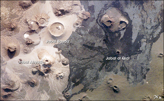
Harrat Khaibar, NASA Photo, 2008
Harrat Lunaiyer is a volcanic range of 50 cones near the Red Sea south of Tebuk and Harrat Uwayurid, north of Khaybar. There is a report of historic volcanic activity such as coals of fire that did not burn out.
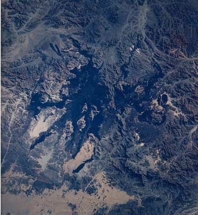
Harrat Lunaiyer, NASA Photo
Concluding statements: Remarks